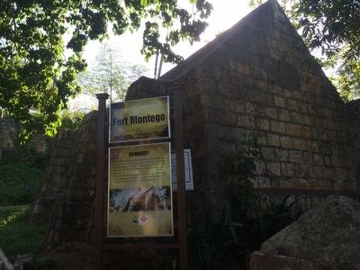
All forts had buildings in which weapons and ammunition were kept safe. These were known as armouries and were heavily fortified buildings. The thick walls provided protection from direct hits, even the roof is built from cut stone to deflect shots . . . — — Map (db m92386) HM
Cannons were used in forts for the defence of harbours. Fort Montego had seventeen (17) cannons mounted in its heyday. Three (3) remain, two (2) dated 1810 and one (1) 1813. These are cast iron cannons manufactured by the Carron and Company Works . . . — — Map (db m92379) HM
The fort was originally built in 1750; it was then known as Fort Frederick, later as Fort George. Fort Montego designed by European engineers, was built by enslaved Jamaicans to guard the town of Montego Bay. Built in the shape of a polygon, the . . . — — Map (db m92385) HM
This tablet commemorates Jamaica’s achievement of independence on the 6th of August, 1962, and the visit of Her Royal Highness The Princess Margaret Countess of Snowdon and The Earl of Snowdon to Montego Bay on the 8th of August, 1962. — — Map (db m129887) HM
Montego Bay On 9th May 1494, Christopher Columbus arrived in Montego Bay during his second exploratory voyage to the New World and named it “Golfo de Buen Tiempo” (Fair Weather Gulf). Following the Spanish colonization of the island . . . — — Map (db m201741) HM
Montego Bay Civic Centre The Montego Bay Civic Centre was redeveloped by the
Urban Development Corporation (UDC) for the St. James Parish Council, from the ruins of the old burnt-out courthouse built in 1804 The UDC carried out this project . . . — — Map (db m129885) HM
The area was settled by the Taino. Columbus arrived in 1494 on the 2nd voyage, anchored in the bay and called it Golfo de Buen Tiempo or the Gulf of Good Weather. The Spanish used it to ship Manteca or Lard from the slaughtering of . . . — — Map (db m92252) HM
The Old Hospital Park
The St. James Hospital, built on the site of an earlier facility, the St. James General Marine Hospital, was opened on November 28, 1929. The Hospital, at that time, was considered a state-of-the-art medical facility . . . — — Map (db m201549) HM
Sam Sharpe was enslaved on both the Croydon Plantation and at a property in Montego Bay in St. James. He was owned by Samuel Sharpe, Esquire, Attorney. He was a man of exceptional intelligence and a Baptist lay preacher. He believed all men were . . . — — Map (db m129853) HM
The Cage The cage dates back to 1806. A belfry was built in 1811. In about 1823 this was replaced with todays building of bricks and mortar. The Cage was used as an overnight lockup for vagrants, drunks, runaways and plantation slaves . . . — — Map (db m129717) HM